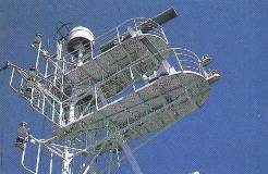
Average depth in the roads is 12m and it allows to handle ships of any carrying capacity. This fact puts the Port of Mariupol into more favourable position in comparison with other ports of the Azov Sea. Navigation in the Port of Mariupol is all year round. Average navigation durability with ice steering (in case of severe winter from December to March) - 86 days. Twenty-four-hours and safe steering of ships in any weather is provided with "Vessel Traffic Surveillance Centre "Rascat" (VTS Centre "Rascat").
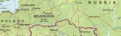
 The Port is equipped with all modern communications including satellite one. The Port takes ships with length up to 240 m and draught up to 8m. Territory of the Port is 67,6 hectares. Length of the Port berth line is 3,2 km. Storage capacity of warehouses is 11 thousand m2. Storage capacity of sheds is 170 thousand m2. The nearest Sea Port are Berdyanskiy, Taganrog, Yeiskiy, Kerchenskiy. Airports:
|
   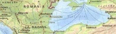
Cargoes sent and taken by the Port have addresses in 60 countries of the world. The Port of Mariupol is connected with 152 Ports of all continents. |